 Setouchi
Region Setouchi
Region
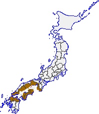
The exact area and boundaries of the Setouchi Region are very
ambiguous and greatly depend on the information
source.
The Setouchi region (瀬戸内地方, Setouchi chihō), or simply
Setouchi, is a geographic region of Japan. Setouchi includes
the Seto Inland Sea and the adjacent coastal areas of Honshū,
Shikoku, and Kyūshū, three of the four main islands of
Japan. Specifically, the Setouchi Region includes the
prefectures of Okayama, Hiroshima, Yamaguchi, Fukuoka, Ōita, Tokushima, Kagawa, Ehime, Hyōgo,
Wakayama, and Osaka, along with their respective coastal
cities.
Also included in this region is the Setonaikai National Park
(瀬戸内海国立公園, Setonaikai Kokuritsu Kōen), one of the first
national parks in Japan. Setonaikai National Park is a
Japanese national park, comprising areas of Japan's Seto
Inland Sea, and of ten bordering prefectures. Designated a
national park on March 16, 1934, it has since been expanded
several times. It contains about 3,000 islands, known as the
Setouchi Islands, including the well-known Itsukushima. As
the park encompasses many non-contiguous areas, and covers a
tiny proportion of the Inland Sea's total extent, control
and protection is problematic; much of the wider area is
heavily industrialized. |
|
|
|
|
|
 Seto
Sea Seto
Sea
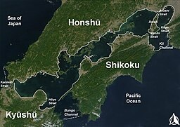
The Seto Inland Sea (瀬戸内海, Seto Naikai), sometimes shortened
to the Inland Sea, is the body of water separating Honshu,
Shikoku, and Kyushu, three of the four main islands of
Japan.
Graphic - The map shows the
boundaries of the Seto Sea.
Click for a larger map
Compared to the Sea of Japan side, the waves are calm on
the Seto Inland Sea. The sea is also famous for its periodic
red tides (赤潮, akashio) caused by dense aggregations of
certain phytoplankton that result in the deaths of large
numbers of fish.
Continue reading.... |
|
|
|
|
|
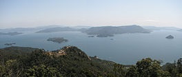
 Seto Sea Islands Seto Sea Islands
What is an island? Well, according to Wikipedia the answer
is, an island or isle is a piece of land, distinct from
a continent, completely surrounded by water. A Google
search for the answer to this question further simplified
the definition, stating that an island is, a
piece of land surrounded by water. Either way, this was
the criteria for estimating the total number of islands in
the Seto Sea of Japan.
Continue reading.... |
|
|
 Setouchi
Region Climate Setouchi
Region Climate
The Seto Inland Sea climate is one of the climate divisions
of Japan. It is also called the Seto Inland Sea climate, Seto Inland Sea type climate, or Setouchi climate. It is
mainly found in the Setouchi region.
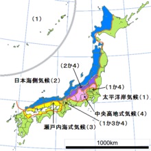
Graphic - The yellow on the
map is the area affected by the Seto Inland Sea climate.
Click for a larger graphic
The Setouchi region is known for its moderate climate, with
a stable year-round temperature and relatively low rainfall
levels.
The seasonal winds are suppressed by the Shikoku Mountains
in Summer and the Chugoku Mountains in Winter, making the
climate more moderate throughout the year, with many sunny
days and little rain. Snowfall occurs about once or twice a
year, but heavy snowfall is rare except in mountainous
areas.
Click for detailed climate information.... |
|
|
|
Insert Setouchi City
Picture |
Setouchi City
Setouchi (瀬戸内市, Setouchi-shi) is a city located
in southern Okayama Prefecture, Japan.
Setouchi
is located in southeastern Okayama Prefecture
(called the Tobi region) to the east of the
prefectural capital of Okayama city. It faces
the Seto Inland Sea to the south, and the
coastline is intricate and forms part of the
Setonaikai National Park. Inhabited islands such
as Nagashima and the Ushimado Islands are within
the city limits. The western section forms part of
the Okayama Plain across the Yoshii River and is
called the Sencho Plain. Most of the area is
mountain forest at an elevation of 100 to 300
meters.
Continue reading.... |
|
|
|
Insert Industry Picture |
Industry
The coastal area has developed into an industrial region,
including heavy chemical industries, and is known as the
Setouchi Industrial Region. The Setouchi Industrial Region
is an industrial area that stretches along the Seto Inland
Sea coast in the Chugoku and Shikoku regions. It is
characterized by a high proportion of chemical substances in
terms of the value of manufactured goods shipped. It belongs
to the Pacific Belt, and is ranked third in terms of the
value of shipments among Japan's industrial zones and
regions, after the Chukyo Industrial Zone and the Hanshin
Industrial Zone. |
|
|
|
|
|
|
|
|
|
|