 Setouchi City Setouchi City
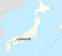
Setouchi (瀬戸内市, Setouchi-shi) is a city located
in southern Okayama Prefecture, Japan. As of 31
January 2023, the city had an estimated
population of 36,499 in 15,934 households and a
population density of 290 persons per km². The
total area of the city is 125.45 square
kilometres (48.44 sq mi).
Google Map - Setouchi City
(new tab) |
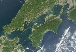
Geography
Setouchi
is located in southeastern Okayama Prefecture
(called the Tobi region) to the east of the
prefectural capital of Okayama city. Several
housing complexes have been developed within the
city. It has become a bedroom community with
many commuters using the Ako Line and National
Route 2. It faces
the Seto Inland Sea to the south, and the
coastline is intricate and forms part of the
Setonaikai National Park. Inhabited islands such
as Nagashima and the Ushimado Islands and within
the city limits. The former Ushimado town in
particular has a beautiful landscape of islands
called the " Aegean Sea of Japan ," and has
accommodation facilities, villas, and beaches.
Between the mainland and Maejima Island of the
Ushimado Islands is the Ushimado Strait (Karakoto
Strait), a scenic spot. The coastal area is
designated as part of the Seto Inland Sea
National Park. The western part forms part of
the Okayama Plain across the Yoshii River and is
called the Sencho Plain. Most of the area is
mountain forest at an elevation of 100 to 300
meters. |
-
Mountains - Nishidaihirayama (327m),
Tokyodaihirayama (302m), Yotsutsujiyama
(260m), Ryuoyama (223m), Tamakatsuyama
(267m), Ohirayama (262m)
-
Rivers - Yoshii River, Sencho River,
Hoshida River, Kado River, Aburasugi River
-
Islands - Nagashima, Ushimado Islands
( Maejima , Kijima , Kuroshima , Aoshima ,
etc.)
|
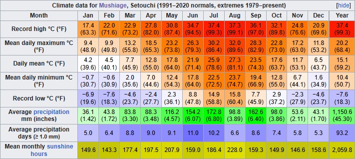 Climate Climate
Setouchi has a humid subtropical climate (Köppen
climate classification Cfa). The average annual
temperature in Setouchi is 15.1 °C (59.2 °F).
The average annual rainfall is 1,150.6 mm (45.30
in) with July as the wettest month. The
temperatures are highest on average in August,
at around 27.3 °C (81.1 °F), and lowest in
January, at around 4.2 °C (39.6 °F). The highest
temperature ever recorded in Setouchi was 37.4
°C (99.3 °F) on 30 July 2004; the coldest
temperature ever recorded was −7.6 °C (18.3 °F)
on 27 February 1981. |
|
|
|
|
|
Demographics
Per Japanese census data, the population of Setouchi in 2020
was 36,048 people. Setouchi has been conducting censuses
since 1950.
|
|
Setouchi Population Statistics |
|
Year |
Population |
Percent Change |
|
1950 |
41,449 |
— |
|
1955 |
40,619 |
−2.0% |
|
1960 |
38,789 |
−4.5% |
|
1965 |
35,814 |
−7.7% |
|
1970 |
33,769 |
−5.7% |
|
1975 |
35,866 |
+6.2% |
|
1980 |
37,939 |
+5.8% |
|
1985 |
38,838 |
+2.4% |
|
|
Year |
Population |
Percent Change |
|
1990 |
38,928 |
+0.2% |
|
1995 |
39,228 |
+0.8% |
|
2000 |
39,403 |
+0.4% |
|
2005 |
39,081 |
−0.8% |
|
2010 |
37,858 |
−3.1% |
|
2015 |
36,975 |
−2.3% |
|
2020 |
36,048 |
−2.5% |
|
|
|
|
History
The area Setouchi was part of ancient Bizen Province. Port
Ushimado was a famous port till the early modern era. It
served messengers from Korea to the Imperial Court and later
to the Tokugawa shogunate. The port is today a good spot for
sightseeing and sailing. Osafune was famous for the
production of katana in the 12th century under the name of
Bizen Osafune. Fukuoka District, which flourished as a trade
center and later a political center along the Seto Inland
Sea until the beginning of the Edo period, served by the
Yoshii River and the Seto Inland Sea, is also included as a
part of the city. The Fukuoka Market (Fukuoka no Ichi) was
recorded in the scroll Ippen Shonin Emaki, drawn in the 13th
century. At the end of the Kamakura period a castle was
built in Fukuoka. In the middle Muromachi period, the daimyō
who governed Bizen province took this castle as their site,
rebuilt and fortified it more than before. Because the
Yoshii River changed its course and most of Fukuoka
including the castle sank under the river, the castle was
abandoned. During the Edo Period, the area was part of the
holdings of Okayama Domain. After the Meiji restoration, the
area was organized into villages, including the village of
Oku within Oku District, Okayama on June 1, 1889 with the
creation of the modern municipalities system. Oku was raised
to town status on April 1, 1952 after merging with five
neighboring villages. The city of Setouchi was founded on
November 1, 2004, by the merger of Oku with the towns of
Osafune and Ushimado (all from Oku District). Its city hall
is the former town hall of Oku.
Chronology |
- On April 1, 1952, the villages of
Oku, Fukuda, Imashiro, Honjo, Toyohara, and Kasaka in
Oku County merged to form Oku Town.
- On January 1, 1954, Tamatsu village
was incorporated into Oku town.
- On October 1, 1954, the towns of
Ushimado, Shikanoshi, and Nagahama merged to form
Ushimado Town.
- On March 31, 1955, part of Omiya
Village was incorporated into Ushimado Town due to a
boundary change.
- On March 31, 1955, the villages of
Miwa , Kokufu, and Gyokou merged to form the town of
Osafune.
- On April 1, 1958, Mokake Village was
incorporated into Oku Town.
- The Oku County Merger Council was
established on August 1, 2002 .
- On March 6, 2004, there was a
signing ceremony for the merger agreement between Oku
Town, Ushimado Town, and Osafune Town.
- On November 1, 2004, the three towns
of Oku-gun, Oku-cho, Ushimado- cho, and Osafune-cho
merged to form Setouchi City. The city name was chosen
through a public contest. Oku-gun was dissolved as a
result of this merger.
|
Government
Setouchi has a mayor-council form of government with a
directly elected mayor and a unicameral city council of 18
members. Setouchi contributes one member to the Okayama
Prefectural Assembly. In terms of national politics, the
city is part of the Okayama 2nd district of the lower house
of the Diet of Japan.
Economy
Setouchi has a mixed economy, based on agriculture, (rice,
pumpkins, cabbage, mushrooms, olives), commercial fishing
(aquaculture of oysters) and industry. Historically, the
area was noted for its production of sea salt and production
of Japanese swords.
Agriculture
The main crops are rice, vegetables including: pumpkin,
Chinese cabbage, cabbage, etc., and fruits including:
grapes, peaches, watermelons, etc. In the Hirayama area of
the former Ushimado town, Mitsukura Agriculture and
Forestry produces mushrooms, boasting the largest share in
Japan. Olive production is also thriving, with Ushimado
Olive Garden boasting the largest olive production in Japan
along with Shodoshima Olive Garden.
Fishing
In terms of fishing, oyster farming is thriving in the
former Ushimado town and the former Oku town, and the
Mushiage area of the former Oku town is particularly
famous for its oyster production. Fishing ports include:
Mushiage Fishing Port, Nishiwaki Fishing Port, Ushimado
Fishing Port, and Kobogan Fishing Port.
Industry
There are only a few industrial parks run by local
governments scattered here and there. Kinkai Salt Industry
once had Japan's largest salt fields in Kinkai Bay, but with
modernization, salt is now produced in factories. A
radio-controlled helicopter and airplane competition is held
once a year on the vast former salt fields site. The former
Osafune town is home to the Benesse Corporation 's logistics
center, and the former Oku town is home to Okayama Murata
Manufacturing Co. , Ltd., located on a vast site along the
Yoshii River. The former Ushimado town is home to Kyokuto
Associates, a major notebook manufacturer, and was once the
headquarters of SEC and Yanmar Shipyards, but all of these
were relocated before the merger of the three towns.
Major companies and factories include: Benesse Logistics
Center, Okayama Murata Manufacturing, Mitsubishi
Agricultural Machinery Sales, Tada Denki Okayama Factory,
Uchiyama Kogyo Oku Factory, Kyokuto Associates Okayama
Factory, Nissin F.D. Foods, Ohayo Dairy Osafune Factory,
Yokoyama Seimo , and Mitsukura, Nippon Olive.
Education
Setouchi has nine public elementary schools, three public
junior high schools, and one public high school operated by
the Okayama prefectural Board of Education.
Transportation |
- Railway
- JR West (JR West) - Akō Line
- Osafune - Oku - Ōdomi
- Highways
- National Route 2
- National Route 250
|
|
|
|
|
|
|
|
|
|
|
|
|